Online platform voor informatie op locatie
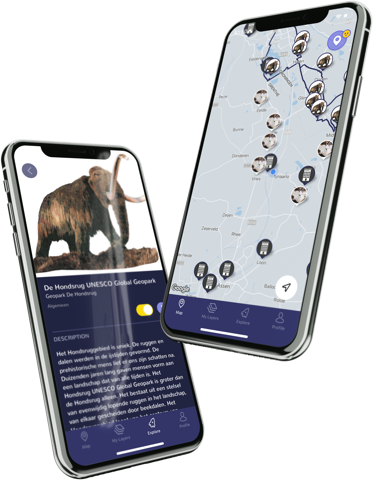
Spacetime Layers is een platform waarop organisaties in een handomdraai een eigen interactieve kaart kunnen maken. Vergelijkbaar met YouTube beheer je als organisatie of afdeling binnen Spacetime Layers een eigen kanaal, in dit geval een layer of kaartlaag. Via een gebruiksvriendelijke interface plaats je je content over Points of Interest op een bestaande kaart en zo wordt Spacetime Layers een interactieve plattegrond voor je doelgroep.
Een eigen app ontwikkelen voor informatie op locatie is dus niet meer nodig. Met Spacetime Layers prik je in op een bestaand systeem en profiteer je van de voortdurende innovatie en doorontwikkeling van het platform. Bovendien bedien je zo niet alleen je eigen achterban, maar die van alle deelnemende organisaties.
Dynamische content
Welke content je in Spacetime Layers wilt bieden, bepaal je zelf. De mogelijkheden zijn eindeloos.
Informatie over bijvoorbeeld gebouwen, voorzieningen, natuur en cultuur en alles wat zich daarbinnen afspeelt. Gepresenteerd in de vorm van tekst, beeld, geluid, een route, een game met augmented reality of zelfs real time informatie zoals camerabeelden of vrije parkeerplekken. Als je wilt, helpen we je om de content op het platform te plaatsen of in te laden. Ook de creatie kunnen we voor je verzorgen.
Of je je nu bezighoudt met werelderfgoed, onderwijs, toerisme, duurzaamheid, mobiliteit, gezondheid of iets heel anders. Je deelt je content in Spacetime Layers om mensen verder te helpen, iets nieuws te leren, zich te laten verwonderen, ergens bij te betrekken of de informatie te laten verrijken.
We denken graag met je mee over de mogelijkheden voor jouw organisatie. Vraag nu de quick scan aan voor een eerste inventarisatie van geschikte content.
Ik wil een quick scanGratis app
De gebruikers van Spacetime Layers krijgen via een gratis interactieve app toegang tot jouw content. Door layers aan- en uit te zetten zie je als gebruiker de informatie waarin je geïnteresseerd bent, op de juiste plaats en het juiste moment. Of je nu in de natuur bent of door een stad wandelt, voortaan heb je van alle, voor die plek relevante informatie een gids bij je in één overzichtelijke app.
Voordelen van Spacetime Layers
Spacetime Layers biedt voor zowel organisaties als hun doelgroepen verschillende voordelen ten opzichte van het ontwikkelen of downloaden van individuele apps over een locatie.

Kant-en-klaar platform
Wat YouTube is voor video’s is Spacetime Layers voor informatie op locatie. Je plaatst je content in een eigen kaartlaag op de interactieve plattegrond. De gebruiker combineert zelf de informatie van alle organisaties.

Kant-en-klare userbase
Elke organisatie brengt zijn eigen doelgroep mee naar het platform. Dus in plaats van verschillende apps per thema en regio, heeft de gebruiker nu één app voor alle informatie op locatie. Deel je gebruikers, vermenigvuldig je bereik!

Geen ontwikkelkosten en lage hostingkosten
Het platform en de app hebben wij al voor je ontwikkeld, jij betaalt alleen een maandelijks bedrag voor het ontsluiten van je content.

Voortdurende doorontwikkeling
Wij beheren het platform en de app, jij de content. Elke nieuwe functionaliteit die wordt bedacht in samenwerking met een organisatie, komt beschikbaar voor alle andere organisaties.
Steeds nieuwe toepassingen
Het idee voor Spacetime ontstond in een Groningse basisschool. Meester Patrick Trentelman maakt een start-up van zijn klas . Samen met softwareontwikkelaar New Nexus bouwen ze een app, Spacetime; een digitale tijdcapsule waarmee je informatie naar de toekomst kan sturen.
Tijdens een stadswandeling met de klas van de Groninger Archieven, beseft Patrick: de wereld is buiten en ligt vol met verhalen die verteld willen worden. Wat nou als je een app bouwt waarin organisaties hun kennis en verhalen locatiegebonden kunnen aanbieden? Een Spacetime met informatielagen: Spacetime Layers.
Inmiddels is Spacetime Layers uitgegroeid tot een platform waarop uiteenlopende organisaties hun locatiespecifieke informatie met hun doelgroep delen. Historische wandelingen, kunstroutes, educatieve gaming - de toepassingen zijn legio.
Zo blijkt het platform ook zeer geschikt voor informatie uit sensoren (Smart City, 5G), evenementen (time-tables op locatie) of het tonen van voorzieningen (invalidentoiletten, watertappunten, etc.). Elke organisatie profiteert weer mee van de nieuwe mogelijkheden.
De mogelijkheden zijn legio
Monumenten, geschiedenis
Lagen van realiteit
Sensoren, webcams, IoT
Stadswandelingen, lokale verhalen
Locatie gebonden
Tijdschema’s
Speeltuinen, mysterieuze tours
Intern verborgen kaartlagen
Berichten van het publiek
Vraag nu een demo-account aan met voorbeelden uit jouw branche.
Ik wil een demo-accountKlanten
Awards
Geïnteresseerd?
We denken graag met je mee over de mogelijkheden van Spacetime Layers voor jouw organisatie. Bel of mail ons met je vragen of voor het maken van een afspraak.
Ga je liever meteen aan de slag? Vraag dan nu een gratis demo-account aan.
info@spacetimelayers.app
telnr. +31 (0) 85 06 88 710
Volg ons op YouTube en Linkedin
Bedrijfsgegevens
Note 2 Self B.V.
Handelsweg 6
9482 WE Tynaarlo
KvK 67354564
Mogelijk gemaakt door  - IT's our DNA
